
7S0
Ronan Airport
Ronan, Montana, USA
Airport Location
| FAA Identifier: | 7S0 |
| Lat/Long: | 47-34-01.8220N / 114-06-03.8600W |
| 47-34.030367N / 114-06.064333W | |
| 47.5671728 / -114.1010722 | |
| (estimated) | |
| Elevation: | 3086 ft. / 940.6 m (surveyed) |
| Variation: | 15E (2005) |
| From city: | 3 miles N of RONAN, MT |
| Time zone: | UTC -7 (UTC -6 during Daylight Saving Time) |
| Zip code: | 59864 |
| Airport Weather Report | Click Here |
Airport Operations
| Airport use: | Open to the public |
| Activation date: | 11/1952 |
| Sectional chart: | GREAT FALLS |
| Control tower: | No |
| ARTCC: | SALT LAKE CITY CENTER |
| FSS: | GREAT FALLS FLIGHT SERVICE STATION |
| NOTAMs facility: | GTF (NOTAM-D service available) |
| Attendance: | UNATNDD |
| Wind indicator: | Lighted |
| Segmented circle: | Yes |
| Lights: | DUSK-DAWN |
| MIRL RY 16/34 & PAPI RY 34 OPER 1600-2100, AFTER 2100 ACTVT MIRL RY 16/34 & PAPI RYS 16 & 34 – CTAF. | |
| Beacon: | White-green (lighted land airport) |
Airport Services
| Fuel Available: | 100LL JET A + PRIST |
| 24 HR. SELF SERVICE FUEL AVAILABLE. | |
| Parking: | Tiedowns |
| Airframe service: | MINOR |
| Powerplant service: | MINOR |
| Bottled oxygen: | NONE |
| Bulk oxygen: | NONE |
Runway Information
| Runway 16 and 34 | |
| Dimensions: | 4800 x 75 ft. / 1463 x 23 m |
| Surface: | asphalt, in good condition |
| Runway edge lights: | Medium Intensity |
| Runway 16 | |
| Latitude: | 47-34.425152N |
| Longitude: | 114-06.064690W |
| Elevation: | 3085.9 ft. |
| Gradient: | 0.1% |
| Traffic pattern: | Left |
| Runway heading: | 165 magnetic, 180 true |
| Markings: | nonprecision, in good condition |
| Visual slope indicator: | 2-light PAPI on left (3.00 degrees glide path) |
| Touchdown point: | Yes, no lights |
| Obstructions | 15 ft. road, 1125 ft. from runway |
| Runway 34 | |
| Latitude: | 47-33.635648N |
| Longitude: | 114-06.063985W |
| Elevation: | 3079.3 ft. |
| Gradient: | 0.1% |
| Traffic pattern: | Left |
| Runway heading: | 345 magnetic, 360 true |
| Markings: | nonprecision, in good condition |
| Visual slope indicator: | 2-light PAPI on left (3.00 degrees glide path) |
| Touchdown point: | Yes, no lights |
| Obstructions | None |
Instrument Procedures
NOTE: All procedures below are presented as PDF files. If you need a reader for these files, you should download the free Adobe Reader.
NOT FOR NAVIGATION. Please procure official charts for flight. FAA instrument procedures published for use between 22 October 2009 at 0901Z and 19 November 2009 at 0900Z.
IAPs – Instrument Approach Procedures
| RNAV (GPS) RWY 16: | Download (689 KB) |
| RNAV (GPS) RWY 34: | Download (721 KB) |
Departure Procedures
| HANIM ONE (RNAV) **NEW** | Download (107 KB) |
| RONAN ONE (RNAV) **NEW** | Download (125 KB) |
| Minimums/Departure Procedures Apply: | Download (107 KB) |
Other Nearby Airports with Instrument Procedures:
- 8S1: Polson Airport (8 nm NW)
- KMSO: Missoula International Airport (39 nm S)
- KGPI: Glacier Park International Airport (45 nm N)
- 32S: Stevensville Airport (63nm S)
- S59: Libby Airport (70 nm NW)
Current Date & Time
| Zulu | 2026-02-24T09:35:51Z |
|---|---|
| Local | 2026-02-24T02:35:51Z |
Fuel Prices
| Type | 100LL | Jet A + Prist |
|---|---|---|
| Self Service | 5.01 | 5.13 |
Airport Ownership & Management
| Owner | Ronan City Hall 207 Main St. SW, Suite A Ronan, MT 59864 Phone: (406) 676-4231 |
| Manager | Bob Snyder 36078 Canon Mill Road Ronan, MT 59864 Phone: (406) 250-4824 |
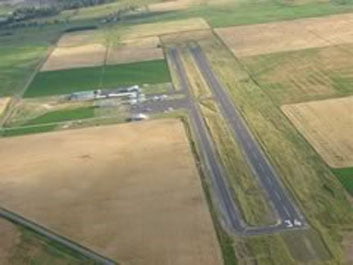
Aerial Photo
Google Map
Sectional Chart
Enroute Charts at SkyVector.com
Airport Operational Statistics
| Aircraft based on the field: | 43 |
| Single engine airplanes: | 42 |
| Multi engine airplanes: | 1 |
| Aircraft operations: | Avg. 73/week* |
| Transient general aviation | 26% |
| Local general aviation | 74% |
Airport Communications
| CTAF/UNICOM: | 122.8 |
| WX AWOS III / AV at 8S1 (8 nm NW): | 119.925 (406-676-2967) http://k7s0.awosnet.com/ |
| Nearby radio navigation aids: | |
| VOR radial/distance: | FCAr163/31.1 |
| VOR name: | Kalispell VOR/DME |
| Freqency: | 113.20 |
| Var: | 18E |
| VOR radial/distance: | MSOr342/39.6 |
| VOR name: | MISSOULA VOR/DME |
| Frequency: | 112.80 |
| Var: | 17E |
| NDB name: | KONNA |
| Hdg/Dist: | 356/37.1 |
| Frequency: | 521 |
| Var: | 17E |
| ID: | INE .. -. . |
| NDB name: | SMITH LAKE |
| Hdg/Dist: | 141/27.1 |
| Frequency: | 515 |
| Var: | 15E |
| ID: | SAK ... .- -.- |
Additional Remarks
- LARGE SEAGULLS ON & INVOF RY. - TAXIWAY REFLECTORS.